Getting Out: While writing a recent column about Garland Park in
Carmel Valley, I was surprised to learn that Monterey Peninsula
Regional Parks District has quite a number of other parks and
preserves. About that time, I received a phone call from Ray, my
ranger-friend at MPRPD, who asked how I enjoyed Garland Park. He
was calling from an overlook in another park, Palo Corona Regional
Park.
While writing a recent column about Garland Park in Carmel Valley, I was surprised to learn that Monterey Peninsula Regional Parks District has quite a number of other parks and preserves. About that time, I received a phone call from Ray, my ranger-friend at MPRPD, who asked how I enjoyed Garland Park. He was calling from an overlook in another park, Palo Corona Regional Park.
“It’s a beautiful morning, and I am looking at a spectacular view across Carmel Bay and the Monterey Peninsula,” he said.
In 2002, the Nature Conservancy and the Big Sur Land Trust partnered with Monterey Regional Parks to purchase Palo Corona Ranch, the largest land conservation project in Monterey County history. At 10,000 acres and 10 miles in length, the ranch is a key acquisition that links together nine other protected properties in the region. The 5,500 acres in the south were added to the Department of Fish and Game’s Joshua Creek Preserve, while the northern 4,350 acres became Palo Corona Regional Park.
Ray’s description of the view had me heading for the door until he told me that access to Palo Corona is by permit only and is temporarily limited to Saturdays and Sundays until trail and road work is completed. Additionally, parking is only available on the shoulder of Highway 1. So until the district builds a suitable lot, they will only issue 13 permits per day.
Don’t let these limitations deter you. I filled out a simple application for a permit at the Monterey Peninsula Regional Parks website for the upcoming Saturday, and it was in my inbox first thing the next morning. No muss, no fuss.
Past the town of Carmel, Palo Corona Park is a mere 200 yards beyond the Carmel River on Highway 1. We stepped inside the locked gate (your permit will have the four-digit combination) and eased across a stretch of wide-open ranch land that reaches out to a high bluff rising beyond. The Palo Corona Trail is a road of bright, newly laid crushed granite that is easy to trace as it edges up and around the bluff. Our goal, Inspiration Point, is somewhere up above and tantalizes with the prospect of the view that must wait there.
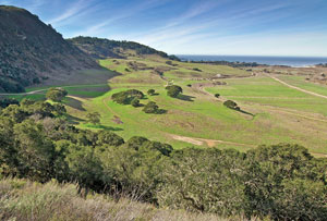
Near the toe of the slope, about a half-mile out, a group of wind-twisted coast live oaks were huddled together, casting long shadows across the green grass as the sun began to clear the hill. From here, the trail angles left up the hill through more oaks and beneath sheer cliffs.
As we rounded the slope, the grade steepened, and we entered a grove of large Monterey pines. In the gaps, we looked beyond Rancho Canada Golf Course at the entrance to Carmel Valley. We kept climbing and turning to the right like a stripe up a candy cane until the trail leveled out. A short scoot up a side trail, and we were at Inspiration Point, 1.6 miles and 600 vertical feet from our car.
Ray was right. It is a grand view over the ranch land below and out to Carmel Bay beyond. We could see Pebble Beach and Stillwater Cove, and much of the Monterey Peninsula. Point Lobos, though very close, was obscured from view by the hills to our left. We walked an easy half-mile further to the end of the trail at lovely little Animas Pond before turning back.
Much of the land on the park map is marked “Temporarily Closed Area.” The day is coming when more of Palo Corona will be open, but what is currently open is worth a visit now.
Hardly a hike, the walk to Inspiration Point felt more like a midday stroll. These sunny spring-like days, before the summer fog arrives, are a perfect time for a visit here.


