Researcher will discuss NASA software for agriculture
Researcher will discuss NASA software for agricultureLocal growers and other interested members of the public will have a chance next week to learn about an emerging satellite software program that could help with conserving water in the county.
The meeting will be held Thursday, Feb. 9 at noon at the San Benito County Water District Office, 30 Mansfield Road, in Hollister.
Shawn Novack, the water conservation program manager for the Water Resources Association of San Benito County, said he learned about the NASA Terrestrial Observation and Prediction System through articles online. When he saw that one of the researchers on the project also works at California State University, Monterey Bay, he decided to invite the scientist to San Benito.
“I’m just one of the people aware of the new technology,” Novack said. “I’m trying to keep local residents apprised that it might assist us to better manage our water and natural resources.”
Forrest Melton, one of the researchers on the NASA project, will talk with local growers and anyone from the public who is interested for 30 minutes to an hour. Novack selected Feb. 9 because there is a morning workshop from 9 a.m. to noon that day about chemigation/fertigation, for which Novack had 30 local growers already registered.
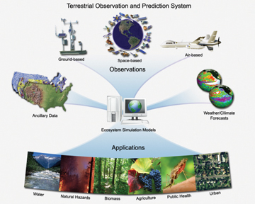
The TOPS program is a modeling software that brings together a variety of technologies such as weather and climate forecasting, ecosystem modeling, satellite remote sensing to enhance management decisions related to floods and other natural disasters and more, according to the NASA Ames Research Center website.
Novack said the researchers working on the application are hoping to make it an app that will be usable by farmers from cell phones so that they can get information on their crops when they are out in the field.
“We already have weather stations that are linked up throughout the state to look at different precipitation and evaporation rates but to get farmers to use it is hard because they have to sit inside on a computer,” Novack said. “They are very savvy on using cell phones. Apps seem to be a better technology for farmers.”
Novack, who said that Melton would be able to explain the uses of TOPS in better detail to local growers, said it would primarily help with water management.
“They will see real-time satellite photos and see areas that are not getting as much irrigation as some or areas that are getting too much irrigation,” Novack said. “They can adjust it to get maximum yield and reduce their costs. I see a lot of possibilities if they can make the technology work consistently.”
The research team is working on more than 20 projects using the software. Those related to water and agriculture include: water supply and management in California, scalable to regional and national applications; development of the viticultural information system; improved prediction of irrigation water use for California crops from remote sensing and integrating NASA earth science research into a crop insurance decision support system.
Novack said in addition to sharing information with local growers they will have a chance to give Melton feedback on the technology.
“He (Melton) might be able to get some input from our area that would help to develop the software better for our use as well,” Novack said.
Satellite technology workshop for local growers
The workshop is Feb. 9, at noon, at the San Benito County Water District, with Forrest Melton, a research scientist from California State University, Monterey Bay who works with NASA Ames.
The program will be able to provide growers with information about crop growth, irrigation demands and forecasts, as well as imagery of their fields throughout the growing season. Details: Shawn Novack at 637-4378 or sn*****@***wd.com.


