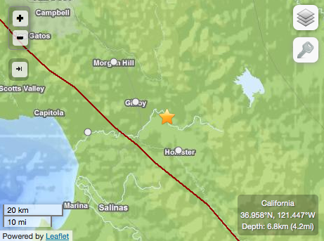
Some say bad things happen in threes, but when you live near Gilroy, Morgan Hill and Hollister – a terrestrial intersection where a handful of earthquake fault lines converge like superhighways (namely, Sargent, Calaveras, Quien Sabe, San Andreas and Paicines) the trio of temblors that popped up in the exact same spot this week is a matter of geographic reality; not superstition.
Most recently, a 2.6 magnitude quake showed up on the grid at 4:37 a.m. today approximately seven miles east/southeast of Gilroy, according to the United States Geological Survey website. This was preceded by a 2.8 magnitude shaker at 1:53 a.m. yesterday in the exact same spot. At 10:14 p.m. Tuesday, a 3.0 magnitude temblor – also in the same area – was rowdy enough to prompt 12 people from Hollister, four from Gilroy and one from Morgan Hill to log onto the USGS website and report they had felt it.
According to the USGS tectonic summary, all three quakes occurred along the Calaveras Fault, the southern segment of which produced two 6.2 magnitude earthquakes in Morgan Hill – the first in 1911 and the second in 1984. It also caused the 5.9 quake at Coyote Lake in 1979.
The 2003 Working Group for California Earthquake Probability assigned an 11 percent probability that the Calaveras Fault will produce a magnitude 6.7 or larger earthquake in the next 30 years.


