
Getting Out: It’s no wonder that countless artists and
photographers have come to Point Lobos for inspiration. If truth be
told, they should acknowledge a little artistic fraud, because
Mother Nature has done the artistry for them.
It’s no wonder that countless artists and photographers have come to Point Lobos for inspiration. If truth be told, they should acknowledge a little artistic fraud, because Mother Nature has done the artistry for them.
A few miles south of the City of Carmel on Highway 1, Renee and I turned into the main gate of Point Lobos State Reserve. Other than a single side road that drops down to Whalers Cove, the preserve’s main road forms a large U that reaches out the peninsula a half mile or so before doubling back along the south shore finally ending on the cliffs at the southern parking area.
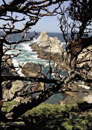
Though we visited on a weekday, parking near the Information Station (at the bottom of the U) was full, so we moved on to the next lot along the point’s south shore. The sound of wind, waves and barking sea lions greeted us as we set out along the South Shore Trail. This sun-baked side of the preserve is open chaparral-covered country that lacks the Monterey Pine forest that shrouds the north portion of the peninsula.
A short walk brought us back to the Information Center where a kiosk and several docents are available with answers to your questions. We headed out along the Cypress Grove Trail. The main trunk of Point Lobos has several fingers that poke out into Carmel Bay. The trail system here is basically a group of small loops that run out each finger and back. The Cypress Grove Trail is one of those lovely loops.
Here, we left behind the open chaparral and entered a grove of Monterey pines, many with striking patches of bright orange lichen. Every scene along the trail and every outlook through the pines was a postcard. Near and far, the sights were so ideal that it was easy to question whether Mother Nature alone was the designer here, or whether some high-priced landscape architect placed every rock and tree just so.
Over here, the Monterey pines filtered light to a forest floor dotted with Douglas Irises and pink hedge nettle. A little further down the trail, an elegant wind-swept cypress tree perfectly accented a rocky promontory that dropped steeply down to kelp-choked coves. The water reflected every shade of blue and green. With each step, the elements changed shape and position, but they were always assembled into a stunning arrangement.
Back at the Information Station, we hopped on the North Shore Trail and began another loop around Whalers Knoll. We turned our backs on the open ocean and looked toward the mainland across Bluefish Cove and Whalers Cove. These calm coves hold glassy blue-green waters nestled at the base of pine and cypress-covered cliffs. This is the Reserve Underwater that protects a rich submerged habitat. The convergence of two temperature zones and a deep underwater canyon close by combine to create a habitat that is home to a wide variety of sea life. Divers with a permit may go have a look.
While a hiker can combine several loops, no one loop is more that 3/4 of a mile or so. String together as many as your heart and legs desire. We turned back at an overlook above Cannery Point, the end of the North Shore Trail. From here, we could look down on the parking lot right on the shore of Whalers Cove. This would be a great spot to park and start your outing.
Point Lobos is not a wilderness hideaway. On the weekends, it is mobbed. But from any spot on any trail, the views near and far will astound you.


