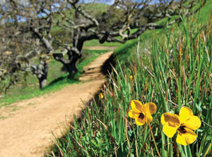
Getting Out: Harvey Bear Ranch County Park encompasses four
undeveloped miles of Coyote Ridge on the east side of Highway 101
that you regularly drive past between San Martin and Gilroy.
Feeling full of piss and vinegar last week, I decided to hike the
full length of the ridgeline, a 10-mile walk in all.
Harvey Bear Ranch County Park encompasses four undeveloped miles of Coyote Ridge on the east side of Highway 101 that you regularly drive past between San Martin and Gilroy. Feeling full of piss and vinegar last week, I decided to hike the full length of the ridgeline, a 10-mile walk in all.
Being lazy by nature, I always head for the Mendoza Ranch entrance up Roop Road about five miles northeast of the Gilroy outlets. While the Harvey Bear Ranch entrance in San Martin is more accessible, it leaves you with a 700-foot climb to the top of the ridge — work I’d rather leave to the internal combustion engine if given the option.
Starting on the trail, a large mountain knob loomed several hundred feet above my head, blocking the view to the west. I passed the Mendoza Trail junction which takes you around that knob and turned right onto the Coyote Ridge Trail which crosses in front of it. About a mile out, the Mendoza Trail rejoins the Coyote Ridge Trail, and the first of many wonderful views of the Santa Clara Valley appears.
Just ahead, I could see the fresh scar of a newly cut trail turning left off the Coyote Ridge Trail. The trail junction had no sign, and it was not on the map I picked up at the parking lot kiosk. What the heck?
Since then, Greg Bringleson at Santa Clara County Parks has set me straight; this new trail is the Gaviota Trail, and it swings out on the valley side of another knob that pokes up from the ridgetop. While printed maps may not include it for awhile, Bringleson hopes the web version will be updated soon, and by the time you read this, the trail signs will be in.
Undeterred by my ignorance, I headed left onto the new trail. The headline act on the Gaviota Trail is a sweeping view of the valley as far north and south as the air quality will allow. Though this trail ultimately joins the Rancho San Ysidro Trail, I noticed another unsigned junction at a small creek crossing that begins with a rock staircase heading back up the hill. Not wanting to drop too far below the top of the ridge, I headed up and shortly rejoined the Coyote Ridge Trail. Bringleson told me this trail is the new Blue Oak Trail, which should also have signs by now.
A short way along the Coyote Ridge Trail, another junction, this time with all the markings.
On the east side of the ridge, the Calaveras Trail rolls through gray pines and forest cover that reveals changing views of Coyote Lake. When we finally get a week or two of warm weather, look for great flower displays here on the open rocky slopes. I passed beautiful carpets of yellow butter-and-eggs that hinted at what’s in store.
Finally, the Calaveras Trail joins the Harvey Bear Trail and turns toward home. But before heading back, I took a short side trip to the Coyote Lake dam and spillway. If you would like to reach this part of the park with less effort, there is a parking area and trailhead at the dam, but to get there, you must pay a $6 day-use fee at the Coyote Lake entrance.
The return trip was more of the same, and that was fine by me. Eat your Wheaties. This is a long walk, but it is a beautiful rolling ramble through grasslands and oaks punctuated with killer views to one side, then the other.


