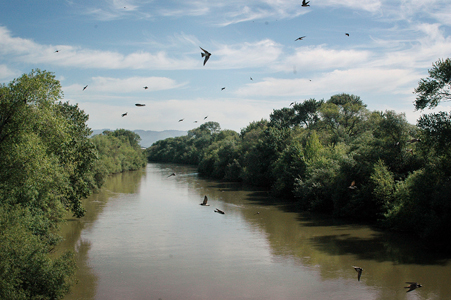
Local waterway named as ‘most endangered’ in the U.S.
The P
ájaro River winds its way through four counties, collecting
contributions from tributaries stretching from Morgan Hill to the
southern reaches of San Benito County before emptying into the
Monterey Bay National Marine Sanctuary. That breadth plays a key
role in efforts by as many as 24 local govern
ment and nonprofit agencies in Santa Clara, Santa Cruz, San
Benito and Monterey counties to protect what last week was named
the most endangered river in America.
Local waterway named as ‘most endangered’ in the U.S.
The Pájaro River winds its way through four counties, collecting contributions from tributaries stretching from Morgan Hill to the southern reaches of San Benito County before emptying into the Monterey Bay National Marine Sanctuary. That breadth plays a key role in efforts by as many as 24 local government and nonprofit agencies in Santa Clara, Santa Cruz, San Benito and Monterey counties to protect what last week was named the most endangered river in America.
And with so many hands in the pot, there are bound to be conflicting views on what needs to be done for better flood control and to alleviate pollution.
While the Pájaro may not be the most polluted or what some would call one of the “worst” rivers in the nation, the nonprofit group American Rivers placed the local waterway at the top of the 10 most endangered rivers list for 2006. The healthy-rivers advocate chooses its top 10 based on places that face the most uncertain future. This year the Army Corps of Engineers is set to make a recommendation for flood control along the river, a move that could effect the future of the river for years to come.
But flood control isn’t the only threat to the habitat and wildlife that call the river home. In San Benito County alone, two proposed development projects totaling roughly 11,000 new homes are being sought within the Pájaro River watershed. That much new concrete and asphalt will, at the least, dramatically increase the runoff into the Pájaro.
“They talk a good story about protecting the floodplain, but the whole development is on a floodplain,” said Lois Robin, a member of the Pájaro River Watershed Committee. “In general, we are opposed to building on the floodplain.”
Working with the local Sierra Club and the Pájaro River Watershed Committee, American Rivers wants to persuade the Corps to use more natural flood controls and to consider the health of the entire watershed in their recommendations.
The stakes in the eventual decision by the Corps include human safety, funding for flood control maintenance and the survival of species living in the river and Monterey Bay.
Two of the main concerns around the river are the best way to keep it from flooding local communities along the lower part of the river and preventing pollution along the waterway.
Flood control
Watsonville and Pájaro were hit hard with floods in 1995 and 1998 despite levee systems completed by the Army Corps of Engineers in 1949 along the lower length of the river.
The 22 miles of levees built along the lower Pájaro were meant to withstand a 50-year flood.
“The Pájaro is a river where the Corps has made a lot of mistakes for a long time,” said Melissa Samet, the senior director of water resources for American Rivers. “This is a year when they have a chance to get it right. It will serve as a model for the rest of the nation.”
The Corps has historically relied on structural fixes to control flooding, Samet said. American Rivers and other environmental organizations believe that levees are a poor fix since there have been repeated floods along the Pájaro through the years.
“Why would you go back in and do the same thing over again?” Samet asked.
The San Francisco District of the Army Corps of Engineers said they have not completed recommendations of flood controls for the Pájaro and will have a period for public comment before a plan is adopted. Recommendations are expected during early summer.
The Corps does agrees with many of the concerns voiced in the report released by American Rivers, according to Maria Or, a Corps’ spokesperson.
“Although it is extreme, a lot of it we do agree with,” Or said. “We know there are issues and that’s why we are out there.”
The Army Corps is currently searching for a local non-federal organization that would be able to pair with them on a study of the entire Pájaro River basin before they make recommendations about flood control later this year.
“That would allow us to implement a more holistic survey,” Or said. “We could look at water quality and other purposes that they stated are important to them.”
Before the Corps can move forward with a study like that, they need to find a local sponsor that will contribute funding. The Army Corps has been in talks with the Pájaro River Watershed Flood Prevention Authority, which is made up of representatives from four counties and water districts, but an agreement to work on a study together has not been made.
“We have talked about it in the past, but they didn’t have the money,” said Nick Papadakis, a member of the board of directors for the Authority. “We didn’t have the local shares. No one had the money.”
The Authority, however, has just completed a $2 million study on the watershed, which includes stream flow modeling and development of flood protection alternatives. While Papadakis said the initial report by American Rivers had some contradictions compared to what the Authority’s consultants found, he said he could not comment on the specifics of the report at this time.
Natural flood protection, the alternative offered by American Rivers, includes a wide-range of options that have been implemented along rivers throughout the United States. In Missouri, 19,000 acres along the Missouri River have been set aside as flood overflow areas. More than 6,000 acres were previously enclosed by levees. The Corps estimated that the changes reduced flood levels in 1998 by four feet, according to the Natural Resource Conservation Service.
Closer by, the Santa Clara Valley Water District moved levees back and created bypass channels along Coyote Creek, which have been credited with slowing flood waters in 1997 by 40 percent and lowering the volume by 57 percent, according to SCVWD.
“Natural flood protection have been used with success in other areas and it makes sense,” Samet said.
The cost of natural flood prevention could also come with a much lower price tag than rebuilding of the current levee system, Samet said.
American Rivers estimated if the Corps decides in favor of rebuilding the levees and adding more of them along the lower Pájaro, it would cost $200 million in construction. Local governments usually pay maintenance costs.
“If you are using a more natural system, you are letting the river function as a river on its own,” Samet said. “Allowing wetlands and restoring wetlands, you don’t have to maintain it.”
Pollution concerns
The Pájaro River has been designated as “impaired” under clean water standards for California. It contributes the worst quality water of any river that flows to the Monterey Bay, according to American Rivers. The river washes nitrates and sediment into the Monterey Bay and is a growing long-term concern.
The Central Coast Regional Water Board District has been testing the quality of the water in the Pájaro, but could not be reached for comment despite two voice mails left over three days.
Nitrates are part of the normal chemical makeup in ocean waters along with more than a dozen other components. The health of the ocean ecosystems relies on maintaining the right proportion of each, according to the National Oceanic and Atmospheric Administration.
In parts of the Gulf of Mexico, nitrates from fertilizer runoffs into the Mississippi River have created hypoxia, or what some fisherman refer to as a “dead zone,” according to the U.S. Environmental Protection Agency. Fish and shrimp populations are drastically lower in the zone, which has lower oxygen levels than needed to maintain marine life.
While the effects on the Monterey Bay from nitrates in the Pájaro haven’t been that drastic yet, changes along the river have driven off some animals.
“In 1995, when there was a flood in the lower Pájaro, all the trees were cut except for one every 75 feet in a misguided move to offer flood protection,” Robin said. “The birds left. They fled and they haven’t come back.”
The river is home to several federally protected species or species of concern, including fish and amphibian species such as steelhead trout, red-legged frogs, southwestern pond turtles and tidewater gobies. Birds that make their home along the river include the western snowy plover, the peregrine falcon and the yellow warbler.
“The people on the committee are determined to see some kind of central management in which the river’s interests come first,” Robin said. “When a healthy river comes first, it will serve the people and creatures the best.”
The committee has worked with scientists who have said mining of sand and gravel in the upper watershed in San Benito County has lead to sediment problems throughout the river.
“Our scientists say (mining) has done several bad things,” Robin said. “It released excessive amounts of sediment. It changed the hydrology of the river so it doesn’t retain or detain as much water.”
Until recently, when the Central Coast Regional Water Board District started testing the river, there have been no regulations of sand and gravel operations in the river.
“People used to swim in this river. There was all kinds of recreation,” Robin said. “We are hoping that eventually it can be maintained in a way that people can enjoy.”
Have your say about the Pájaro River
American Rivers:
www.americanrivers.org or 202-347-7550
Read the report online, then click “Take Action Now” to let government officials know how you feel.
Pájaro River Watershed Flood Protection Authority:
www.pajaroriverwatershed.org
Read their Pájaro River Watershed Study and find out whom your local representatives are.
Pájaro River Watershed Committee:
831-464-1184 or 408-847-3803
Find out more about the watershed and how you can get involved with local efforts.


