If you are of a certain age, you may remember hearing about Mineral King long ago. In the 1960s, Walt Disney planned to develop a ski area in this region at the very southeast corner of the Sierra Nevada. The original proposal met no resistance from environmental groups, but when the plan grew to 27 lifts and an estimated two million visitors per year, the Sierra Club and other groups united to fight and defeat the project.
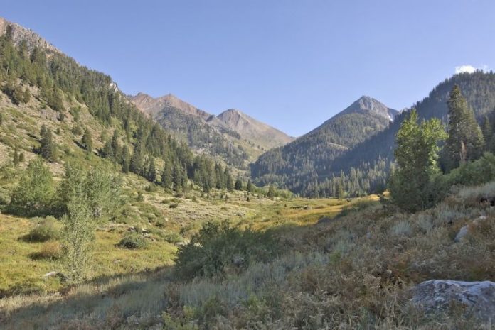
Several years ago, I visited Mineral King and was knocked over by this beautiful gentle valley wedged between impressive granite walls. Like some too-perfect picture postcard, the scene irresistibly beckons. On my first visit, I was fortunate to be guided on a hike to White Chief Canyon by local icon Louise Jackson, but there was so much more to see.
A half hour east of Visalia, a very inconspicuous Mineral King Road branches off of Highway 198 and begins the longest twenty-five miles you will ever drive. This steep serpentine road rises from an elevation of 850 feet to 7,400 feet over rough poorly pothole patched pavement that often pinches down to a single lane. The 25-mile ordeal takes 90 minutes and by the time you get there, you will feel as though you drove across the country.
There is nothing special about the forested country leading to the Mineral King Valley, but near the end of the road I emerged from the pines, swung to the right and there it was.
What an alpine scene! On my left, steep granite walls rose to the 12,000-foot peaks of the Great Western Divide. Raucous mountain streams spilled down the creases in the bare rock wall. Up high, groves of widely spaced foxtail pines stood as huge lonely monarchs dotting the granite rubble.
Yet, between the powerful and imposing valley walls rests the gentlest and most peaceful valley. Here, the frothy cascades gather and rest. Green grass, willows and an assortment of mountain wildflowers accompany the just born East Fork of the Kaweah River—for now a quiet and lazy stream. At the head of the valley, six miles beyond, Farewell Gap looked more inviting and accessible than any Sierra mountain pass could possibly be.
There are several trails that climb out of Mineral King Valley, but the most irresistible heads straight up the valley floor. I left early one morning headed for Lower Franklin Lake, six miles and 2,500 vertical feet away. After a couple flat miles along the valley floor, the trail began to gently edge up the eastern wall and cross a frothy tumbling Franklin Creek. Gardens of columbine, penstemon, leopard lilies, rock fringe, blue flax and so many more kept me company the entire way.
At four miles, the trail doubled back—still edging up—toward Franklin Creek and the lake above. Now, I was in high open country passing through occasional open groves of foxtail pines. What a tree—the quintessence of stout but gnarled resistance to the winds that rake this bare rock slope.
Franklin Lake was not a calendar pin-up lake, but nevermind, every inch of the walk was wonderful. Cascading streams, sweeping views, constant gardens, foxtail pines, the intoxicating altitude—there was never a dull moment. Back on the gentle valley floor, feeling 12 miles of tired, I realized I had not seen another person all day.
It is easy to see what enchanted Walt Disney about Mineral King. I was pleased that Walt didn’t get his ski resort.


