Our California hills prefer to roll along, rising and falling in gentle gradients. There are few trails etched high into steep slopes where a misstep is costly, or where one dreams of tilting forward and taking flight. Not many, but there are a few.
Two friends joined me for a hike along the portion of the Bay Area Ridge Trail that runs through Skyline Ridge Open Space Preserve. Skyline Ridge OSP is a link in the chain of preserves that dot the crest of the Santa Cruz Mountains along the San Francisco peninsula. We set out from a parking lot at the intersection of Page Mill/Alpine Road and Skyline Boulevard, which marks the boundary between Russian Ridge OSP to the north and our destination, Skyline Ridge OSP.
Steps from the car, a tunnel took us under Alpine Road to Alpine Pond just on the other side. Daniels Nature Center, open on Sundays from April to November, sits on the edge of the pond under a lovely forest of Monterey pines. The observation deck at the nature center and the wheelchair accessible trails make Alpine Pond a handy natural retreat for families with young ones or people with limited mobility.
From here, all routes head south and contour across the slope curving in and out of mountain creases that face the Pacific Ocean. Some paths are old farm roads, but preferring a footpath, we caught the Ipiwa Trail at the lower end of the pond. Quickly, we were in a forest of oddly shaped interior live oaks. Rather than a single trunk, these large mature trees each had multiple massive trunks rising from the ground in a pattern more characteristic of a shrub.
Just as quickly, we emerged from the forest into open grassy slopes and a sunny spacious landscape. When planning a hike in these peninsula hills, carefully consider the likelihood of fog. We enjoyed a clear view to the coast, but in windswept foggy conditions, it can be brutally cold and visibility can be measured in yards.
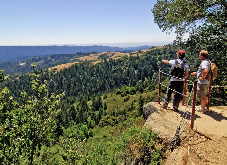
Down the trail, grasslands gave way to chaparral and the slope beneath us grew dramatically steeper. We paused at a railed overlook chiseled into a large sandstone outcrop. Taking in the view from this grand perch, I felt like an airborne wing-walker in the days of barnstorming biplanes. Beneath us, the conifer-covered hills cascaded steadily for miles down to the fogbank that nestled against the coastal hills.
Beyond the overlook, a mile into our walk, the trail turned sharply around the nose of the ridge where we met the Sunny Jim Trail, a dirt road that began the descent toward Horseshoe Lake.
Near this trail junction, I was struck by a small grove of pine trees that seemed out of place. We nature nerds know that pine trees bear needles in groups that are bound together by a papery sheath at their base. The number of needles in the bunch is a key to identifying the tree. Like the lodgepole pine, common in the Sierra, these were two-needled pines. I decided they must be beach pines, a smaller cousin of the lodgepole pine that usually inhabits oceanside bluffs. I have seen beach pines near Mendocino, but never this far south, nor this far from the shore.
Past lovely Horseshoe Lake and across the dam, we turned onto Fir Knoll Trail and climbed gently into a forest of Douglas fir before retracing our steps toward home.
Pick a fog-free day and walk this portion of the Bay Ridge Trail. This four-mile hike delivered changing landscapes and views that will stir your soul.


