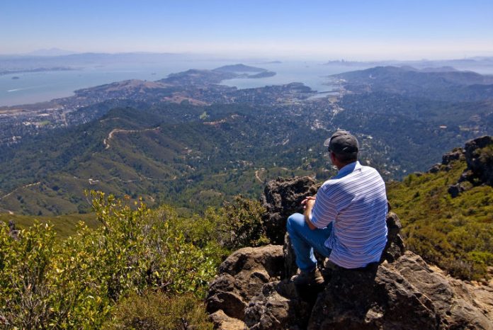
Where on earth can you stand and from a single spot see Mt. Diablo, Mt. Hamilton, the Farallon Islands, and Tomales Bay by Pt. Reyes National Seashore? Of all the great views from the Bay Area’s summit peaks, the panorama from the top of Mt. Tamalpais takes the cake. In addition to those far-flung spots, Angel Island, the San Francisco skyline, and the entire expanse of the north Bay Area lay beneath you as if you are seeing them from the window of a jet airliner.
I grew up beneath Mt. Tam and wandered the mountain as a young boy. But I have only walked to the summit once before (after all, there is a road to the top), and I did that by a different route. So, I asked Charlie, an old friend who still lives in Mill Valley, for his suggestion, and he agreed come along and be my guide.
Along with two friends, Jim Yinger and George Everhart, I drove along Panoramic Highway above Mill Valley to the Mountain Home Inn, a Tamalpais landmark since 1912 and a major trail crossroads. There are a myriad of hiking options from this spot including a short descent to Muir Woods National Monument, but our focus was in the other direction and an attention-getting 1,500 feet overhead.
We walked a steep half-mile up the Hogback Fire Road that died into the Old Railroad Grade Road cutting lazily across the slope. Our brief level walk ended at the foot of the Fern Creek Trail that turned steeply up – sometimes over stair steps – through a narrow crease the mountain. Coast live oaks and tanoaks shaded the lower portion of the trail alongside a small creek that I was surprised to see running this late in the season.
The trail climbed above the forest into a sea of chaparral. Finally, we reached a large parking lot – the end of the road up the mountain, but still a short climb beneath the long closed fire lookout on the very top of the mountain.
Sitting among the rocks beneath the lookout, we named off familiar landmarks around San Francisco Bay too numerous to mention. Behind us, on the back side of the mountain, the lands of northern Marin cascaded out to Pt. Reyes National Seashore and on to the horizon. It was truly a remarkable view.
From 1896 to 1929, elegantly dressed San Franciscans looking for a day in the country would take the ferry to Sausalito, catch the train to Mill Valley, then hop on the twisty Mt. Tam Scenic Railway to the top of the mountain. They returned in open gravity cars to Mill Valley, or after changing cars at the Mesa Station, down to Muir Woods. Our route down was along the same gentle meandering railroad bed followed by those historic gravity cars.
The hike to the top of Mt. Tam doesn’t match the challenge of Clouds Rest, but it is a worthy mini-challenge. We walked about seven miles and climbed 1,500 feet. When we reached the car, we were happy to see it. On Saturday morning, November 9, at 10:00, let’s meet at the Mountain Home Inn and do the same route together. Details will follow. Until then, join me for a couple hikes to stay sharp.
Sept.7 — Whiskey Flat Trail, Pacheco State Park. A rolling 5-mile out and back hike with great views of Pacheco Peak. 9:00am at parking lot on top of Pacheco Pass.
Oct. 5 — Cañada de Pala Trail, Joseph D. Grant County Park. Rolls along a ridge top beneath Mt. Hamilton. A bit of a drive, but a very special hike. 10:00am Twin Gates parking lot.


