Even though I have lived most of my life in the San Francisco Bay Area, I have never spent much time in the East Bay. I often travel through on the interstate highway corridors that take me in and out of the Bay Area, but I very rarely probe the back roads.
Margaret and Beth are two hikers who regularly come down from Walnut Creek to join us Mt. Hoffman Challengers on our spring hikes. They have politely let me know there is a vast resource up their way I should explore. And quite a resource it is! East Bay residents are rightly proud of the East Bay Regional Parks District, a system comprised of 65 parks totaling 119,000 acres and 1,250 miles of trails. I’d better get going.
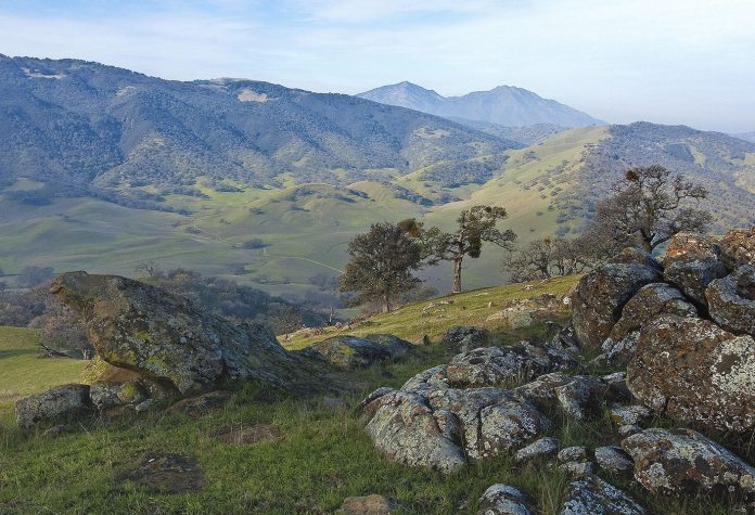
But where to start? With so many parks to choose from, and only my ignorance to guide me, I was adrift deciding where to go. I grabbed my copy of “East Bay Trails,” looked at the cover and my problem was solved. From high on a hill, the cover photo was a view that reached across a huge expanse of classic California hills. Oaks and green grass—that was all—as far as the eye could see. That’s where I wanted to go.
After some page shuffling, I learned the photo was taken at Round Valley Regional Preserve in the hills east of Mt. Diablo. Little did I know, this preserve would be a revelation and after I traveled the full length of the road that led to Round Valley, I also discovered a side of Contra Costa County I never knew existed.
I turned north onto Vasco Road, the last exit on Interstate 580 before the highway begins its ascent of Altamont Pass. Fourteen miles up Vasco Road, I turned left at Camino Diablo Road. Five miles ahead, now on Marsh Creek Road, I reached the preserve.
The trail system at Round Valley Regional Preserve is essentially two gnarled loops that touch at a point somewhat like a disfigured numeral eight. Hidden behind the hills, a couple miles from the road, one loop circles a vast level meadow—Round Valley itself. But the views I came to see are on the other loop high above the valley floor.
Immediately across the footbridge that spans Marsh Creek, I turned left onto Hardy Canyon Trail and began my clockwise march around and over the hills before me. The first half-mile of the trail edged gently across the slope more than climbed it, until I met High Creek. Here, I entered a narrow gorge and began to climb in earnest. The trail ascended through a sunlit blue oak savannah. Even as the canyon narrowed and the walls steepened, the wide spacing of the leafless trees kept the scene bright and cheerful.
As I crossed the dam of a cattle pond, the trees receded and revealed a broad grassy hillside inhabited by grazing cattle feasting on the fruits of our December rain. Around a little bulge in the hill, I saw a saddle just ahead. That must be where the view is.
Sure enough, and what a view! There are very few places in the Bay Area where one can look across such a vast setting without seeing a single man-made structure. The quick drop from the saddle to the broad valley 700 feet below was part of the dramatic effect, but the interplay of grassy valleys and oak-studded hills just kept unfolding, on and on. Beyond everything, anchoring the view, stood Mt. Diablo.
From the saddle, the Hardy Canyon Trail descends to Round Valley Creek where a hiker can turn left into Round Valley or turn right onto the Miwok Trail and follow the creek for a gentle two-mile stroll back to the trailhead.
The Hardy Canyon Trail/Miwok Trail loop is an invigorating 4.8 miles, with a world-class view easily worth every mile in the car and every heart-pounding step it takes to see. Be sure to walk this loop in a clockwise direction or the view will always be behind you. If you have the time, do what I did and continue north on Marsh Creek Road (it becomes Clayton Road) through lovely country I never suspected was hidden away in this corner of the Bay Area.


