After years of writing this column, I sometimes feel a little cocky thinking I know virtually all the nearby parks and preserves. A couple weekends ago, I led a trip into the remote east side of Henry W. Coe State Park. A woman who was on the trip told me about a preserve I had never heard of in Watsonville that she loves and hikes regularly. So much for my comprehensive knowledge.
The 402-acre Bryne-Milliron Forest is tucked under the crest of the Santa Cruz Mountains above Corralitos outside Watsonville. Just getting there is an adventure that takes you through lovely country. At the famous Corralitos Market and Sausage Company, I turned onto Browns Valley Road and drove three more miles into the Roses of Yesterday driveway. The preserve is another mile up a one-lane two-way road. I did not meet any oncoming traffic, but if I had, someone would have needed to do some nifty backing-up.
While Roses of Yesterday was only a waypoint on the trip to Bryne-Milliron Forest, it is an interesting place that deserves mention. Founded in the 1930s, Roses of Yesterday is a one-of-a-kind nursery that offers many old and rare rose varieties. Prices and payment instructions for this self-serve nursery are posted on the wooden entry gate to the fenced property. Years ago, Renée and I bought a two climbing rose there. It was a unique experience to roam the quiet grounds alone, choose your rose, then place your payment into a slotted box at the kiosk. All transactions are made on the honor system.
Two habitats intersect on the ridge that comprises the Bryne-Milliron Forest. The creases hold dense redwood forests while higher south-facing slopes have mixed hardwood forests of coast live oak, tanbark oak and some chaparral species. The preserve’s 10-mile web of trails begins at the parking lot at the bottom of the property. I decided to walk counter-clockwise around the preserve’s perimeter along the Bryne Trail, taking detours as I wished.
Up the hill, I quickly left the oaks behind and entered a dense forest of redwoods and Douglas firs. Like most of our redwood forests, this land was clear-cut in the late 1800s and again after the 1906 earthquake to build San Francisco, but there were some impressive second growth trees rising from the crowns of those long-gone giants.
Three-quarters of a mile above the parking lot, the Leonard Bartle Trail descended steeply into a quiet creek bottom where the redwoods seemed to wrap around me like a fleece comforter. The still trees, moss covered stones and the redwood duff underfoot muffled every sound. I would not have been the least bit surprised if a gnome had stepped from behind a tree. If they exist, this is where they would live.
In fact, at the “Cathedral” Rest Spot, a few gnomes were there to welcome me. Jeff Helmer has been the caretaker of this forest since 1987. As I learned throughout the day, Jeff has left notebooks, water and little trinkets throughout the forest to greet passing hikers. Next to a bench at the “Cathedral” Rest Stop, little knick-knacks, including several little gnome figures, were set on a nearby log.
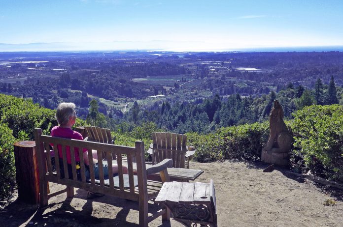
I climbed steeply back up to the Bryne Trail and followed it to Ridge Top Road, which took me to the highest point in the preserve. The dense redwood forest gave way to a brighter woodland of coast live oaks and tanbark oaks. Suddenly, the oak forest opened up and all of Watsonville and the Monterey Bay appeared below me. At AJ’s Point of View, the caretaker once again left an array of benches, chairs, water (for your dog as well) and knick-knacks that made me feel like an expected friend. A quarter-mile higher, the trail ended at “Eagle in Tree” Vista, another spectacular overlook and the highest point in the preserve.
Bryne-Milliron Forest is indeed a hidden gem. Very few places combine an enchanted redwood forest and bright rest stops with expansive views in a comfortable five-mile walk. Visit landtrustsantacruz.org for driving directions and a trail map. Note that the entry gate is open from 9 a.m. to 3 p.m., so don’t visit for a sunset. And be sure to bring your sense of direction. Very few signs mark the trail junctions, so keep the map handy and track your progress on it as you go.


